Maps, Photographs, and Art at Yellowstone Gateway Museum
Selections from the Permanent Collection is a show that explores some of the framed pieces in the collection from early maps of the area to contemporary Park County artists.
Visitors can experience a map published by the U.S. Government in 1867 after many expeditions, including the Corps of Discovery in 1806, added to the knowledge of this area’s geography. Captain William Clark mapped the Livingston area in 1806. The final US Army expedition was led by Captain William F. Raynolds, Corps of Topographic Engineers, to map the Yellowstone River to the North Platte River and explore the headwaters of the Powder, Wind, and Missouri Rivers. He was assisted by 1st. Lieutenant H. E. Maynadier, 10th Infantry. Infantrymen escorted Raynolds and his eight assistants, including topographers, a geologist, naturalist, astronomer, meteorologist, and physician. Fur trapper Jim Bridger guided the expedition.
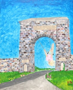
My Playground by Katie Maloney Udd
Other maps include an 1883 Montana Territory Map and 1893 USGS geology and topography maps.
Original works of art by Freeman Butts (acrylics), Maude (Bottler) Daggett (oil pastels), Katie Mahony Udd (acrylic), and Tom L. Roberts (oil) are on exhibit.
Several prints are on display, including hand-colored prints of Yellowstone National Park by William Henry Jackson and an oil painting of downtown Livingston by David Swanson. Three images of Yellowstone National Park subjects were taken by photographer Jeff Henry and a remastered image by F. J. Bandholtz immortalizes downtown Livingston in 1909.
Visit www.yellowstonegatewaymuseum.org to learn more.


